Summary today's session.
Roman's presentation. Roman opened the session with his urban presentation. He has been working and the result has been great with some changes. Mainly, he use a unitary graphic language which made easier the speech, organized the presentation by points and used it as keywords, and he delete some parts which created problems for understanding and he showed clearly the main concepts.
O. Neurath Challenge. We watched David McCandless conference and was really interesting. We where talking aboute the competition and how we can use all the information we have.
new O.Neurath atlas from comparative sketches / diagrams - based on flows / routes / ????
It is was difficult to define more the "what?" part. It was decided to create the medium for sharing ideas, references and resources. It was selected google docs as the main tool to share the text information and work all together in common, and mural.ly to post the graphics works.
jueves, 15 de noviembre de 2012
martes, 13 de noviembre de 2012
A challenge

detailed information about the competition: http://www.archplus.net/home/outofbalance_e
to be discussed:
1. TOPIC
ideas so far:
a) El Cabanyal
b) (inhabited) housing developments built during the last 10 years in a certain area
c) Benidorm
2. REGISTRATION
-Registration till 30th November
-Registration till 30th November
-max. 10 members: who would like to take part? -need full names and profession if other than student
-if you agree I could be the contact person, the final A2 need to be send to Aachen and national post will be cheaper than international.
-if we are less than 10 it would be nice to invite people from other disciplines such as designers or historians, geographers, sociologists, economists... who could help us read the information differently
So far I have on the list (because of the comments/e-mails replied):
1. Paula Cardells (architect/urban planner)
2. Rafael Temes (architect/urban planner)
3. Aitor Deza (student)
4. Pablo Lambertos (student)
5. Alfonso Fernández (student)
6. Albert Brenchat (architect/urban planner)
7. Sara Mira (student)
8. Lucía Martínez (architect/urban planner)
Let me if I'm wrong please!
@Aitor, Albert: did you finish?
3. INTERNAL DEADLINES
I think it would we a good idea to check the calendar and see which goals could we reach by certain dates. I would suggest to have weekly deadlines with smaller amounts of work rather than a few with loads of work. what do you think?
Final deadline is 31st January
4. GROUP ROLES: If someone thinks has a special skill to play certain rol within the group please let the others know!
jueves, 8 de noviembre de 2012
UNIVERSE WEEK CONFERENCE
The following fragile's conference is being prepared... so are you?

Review last year's event
papers photos


Review last year's event
papers photos
lunes, 3 de septiembre de 2012
Tokio from its rivers
Dear all,
I hope you enjoyed your summer,
During my relatively pleasant stay in my town's library, I found an interesting book, published by Taschen, about 100 famous views drawn by Hiroshige.
 This first map, found on the internet, shows precisely the shape of the old genuine city of Tokio, Edo.
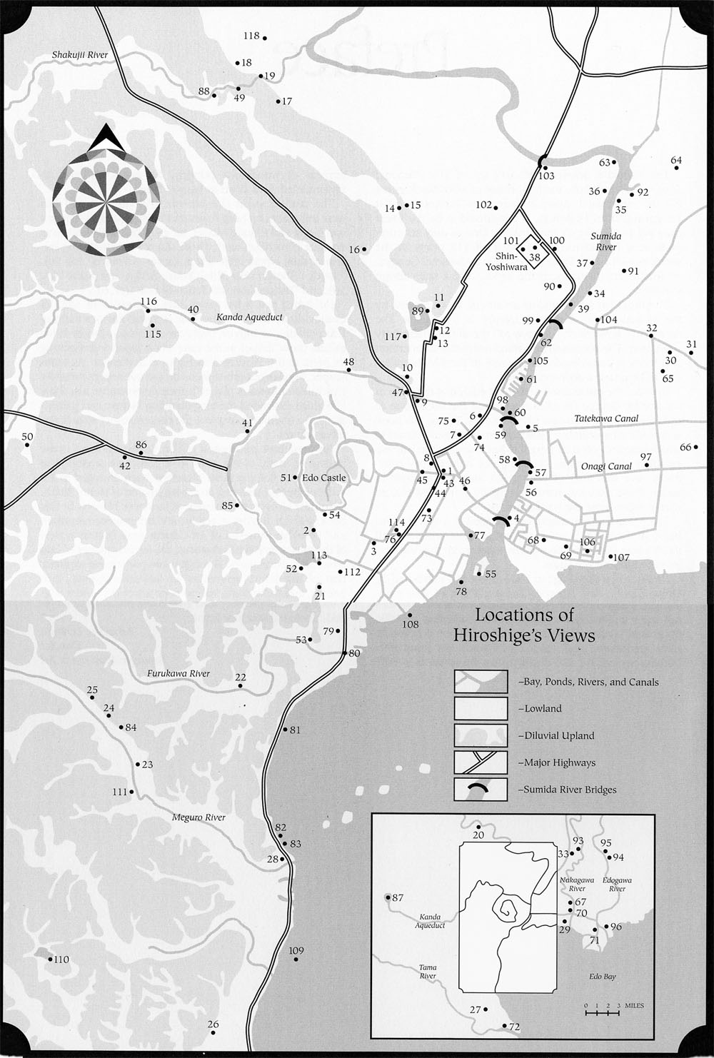
This second map, from the book, is an abstraction of it. The most interesting thing from my point of view, is the sketch at the bottom on the right. The rivers enclose, first the city, and finally the palace.
One conclusion could be that the city, could be drawn and maybe should be, from its rivers, channels and from its centre, the imperial palace.
sábado, 2 de junio de 2012
Alexandre Chemetoff in the IFV: The challenge of the city
Alexandre Chemetoff is a french architect, urban planner and landscape artist, author of the plan for the urban regeneration of the island of Nantes.

To readapt an obsolete industrial area in the middle of the Loira river into city, that was the aim of the plan for the island of Nantes. An original plan for its length (9 months), its scale or its social programme.
The main challenge was to respect the memory of the places, to promote public space by the rivershore and to activate the citizen participation, so they developed the plan in collaboration with a public corporation, the SAMOA (Société d'Aménagement de la Métropole Ouest Atlantique).

As a result, today the district has 18000 inhabitants, 10000 housing units, 16000 jobs and several equipments, such as schools, faculties, and cultural spaces, most of them in former industrial buildings.
"We wanted to find a dialogue with the exisiting, and we found ourshelves making archeology of the future"
Alexandre Chemetoff
- Île de Nantes project webpage
- SAMOA web (Société d'Aménagement de la Métropole Ouest Atlantique)
- The project in the Nantes municipality webpage
- Île de Nantes in Wikipedia
jueves, 19 de abril de 2012
Summary 18th April 2012
Basically the decission-making we proceeded yerterday, was created form the ideas that Manuel Cerdá gave Paula about his presentation
His presentation: 4:05 -5.00 pm
The discourse stems from the concept of dividing wall, which lacks in the japanese culture.
Our presentation: 4.00-4.05 pm
We would like to finish in the same way he begins. It could be a good idea to end up with a zoom in of the Tokio city map, as close as possible so as to see the features of the city configuration, specially the dividing wall one. (If you look closer you will perceive the empty space between buildings)
Sara has found a special music for the event. Hopefully we can hear it next monday. It is extracted from the o.s. from the Shichinin no samurai film (Seven Samurai) directed by Akira Kurosawa
We will draw three zooms in three differents ways of representation
_1st zoom: JAPAN
_Displayed in the projection as an eye's bird image
_Drawn (analitically) in the blackboard
_Drawn in an artistic way (synthesized) in the table and transmitted to the projector by camera
2nd zoom: TOKIO CONECTIONS
_Projection
_(analitically) blackboard
_(synthesized) projector by camera
A video from 2nd zoom to 3rd would be ideal to explain completely where the next area is
3rd zoom: TOKIO DISTRICT
_Projection
_(analitically) blackboard
_(synthesized) projector by camera
martes, 27 de marzo de 2012
TS_27.03.12
SUMMARY of the last session:
_ presentation for Japanese cultural week.
We have decided the 3 different steps in order to show our aim: be able to have an idea about Japan and Tokyo are/work.
o Japan_scale. We decided make the 8 o’clock scheme in order to explain the most important part of the geography. The main point will be Tokyo in the top of the bay.
o Tokio_natural_system_scale. We need to show how are organized the rivers, lakes, mountains, bays and valleys, in order to understand the creation of the old cities. It is important introduce “hitos” like names, words, or emblematic places to help the audience keeping remember how is made every picture.
o Tokio_city_centre_scale. We focussed the picture in the imperial palace, and try to speak what you are going to find in Tokyo when you visit it. We draw the 3 circles and 7 axis scheme, showing the relation of the city with the bay, and putting emblematic (cultural, architectonic, natural, historical, technological) points on the picture.
We concluded the last session closing the performance-presentation with those 3 scheme/pictures.

TS_24.03.12
SUMMARY of the last session.
The aim of the session was develop the way and the skills those we can count on. And develop a second scheme of the presentation (apart of Japan_scale)
o The first part of the session was based on the skills for representing our presentation
___We found the Japanese paintbrush as a good instrument to define the line-drawing parts and the sponge+ gouache to fill solids. The finger-pointing is going to be used for marking.
o The second part of the session was based on the development of the second scheme.
___We took a metropolitan scale, between the two main rivers of the city and the bay, showing the city centre.
___We found a system of representing the map, after draw the bay, and the 2 main rivers, we marked the “imperial palace”, which is going to be the middle point from we made 3 concentric circles and we also crossed 4 cardinal axes, and 3 diagonal ones, which are the communications to the rest of the country.
___We realized that we need and intermediate scale to show the importance for the city the relation with the mountains and the sea.
___We realized that we need fixed some emblematic points to make easier and more interesting the representation.
___We thought to make some stickers or something similar to mark these points with something on the board/on the picture.

Japanese_scale, trying different skills

metropolitan scale

during the session
viernes, 23 de marzo de 2012
TS_21.03.12
SUMMARY
the last session was resolved by this scheme:
__ was projected the global image of Japan and we tried to define in a quickly way the country (basically the 4 principal islands) after a short explication of the main cities/ councils/ metropolitan areas/ .../ Right now, we will keep thinking in this way and develop some skills in other to show more with less.
__ the second image was from the metropolitan area of Tokyo. we decided put other bigger scaled to show the context of the bay.
__ need to research the geomorphology of the area (rivers, mountains, valleys, beaches...)
need to research about the historical develop of the city (non-city)
need to research about drawing and graphics resources to present it
the next session is not programmed yet.
see you, keep safe and best wishes.
***some mental notes: scheme of 8.00 o'clock / Tokyo as a middle point of the circle - Japan flag / Tokyo as a middle reference point of the archipelago / 24x26km / south bays-south cities / performing the presentation/ ...
***some images are enclosed

Suscribirse a:
Entradas (Atom)